Source Maps
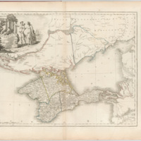
These are the core historical maps which I have mined for spatial data. I have used them to help me locate places that no longer exist, as well as to think about how Crimean space was conceptualized - and how places were defined in relation to one another - in the 19th century.
Topographical map of the Crimean Peninsula
You are looking at a fragment of a topographical map of the Crimean peninsula published in 1842 by the Military-Topographical Depot of the Russian Army. The map was built from the triangulations of Lt. Colonel Oberg and topographical surveys…
Vil'brekht's map of Tavrida Province
Atlas sheet depicting Tavrida in 1792. At the time, the region was an oblast', rather than a guberniia.
Mukhin's Map of Crimea
The dedication of this 1854 printing of Mukhin's original 1817 map reads: "To Her Most Gracious Majesty Queen Victoria, and the allied armies of France and England, this military topographical map of the Krima Peninsula : constructed and founded on…
Keppen's map of Southern Crimea
This digital copy of Keppen's map was made from a copy of an edition of the map held by the library of the Soviet Academy of Sciences. The map has four sheets; the digital version contains 8 images.


